Posts in Category: mountain
Yellowstone! Pilot and Index Peaks in Autumn

Not quite in Yellowstone National Park, but on the boarder in Montana, Pilot and Index Peaks dominate the skyline from the east, coming down off the Beartooth Highway into Cook City. The fall foliage in the foreground marks the season. Sony a6700 with Tamron 50-400Di3 at 117mm equivalent. Program mode. Processed in Photomator.
Beartooth Highway: Above Timberline


The strange alpine landscape of the Beartooth Mountains just east of Yellowstone National Park, above timberline. Lots of lakes in the deep valleys. Sony a5100 with E10-18 f4 at 15mm equivalent. Superior Auto with Landscape scene mode selection. Processed in Photomator.
Yellowstone! From Blacktail

We made one more run up over Blacktail Plateau, past where the carcass was earlier in the morning, just to see what was happening. The scenery was gorgeous…the light just coming across the plateau almost horizontal, and picking out the mountains to the north. Sony a5100 with E10-18 f4 @ 15mm equivalent. Superior Auto with Landscape scene select. Processed in Photomator.
Tetons! From the Snake

I hope you are not getting tired of the Grand Tetons already. We only had a late morning and early afternoon there but the autumn scenery was spectacular. We drove a barely a road down off the highway right down to the banks of the Snake River for a different perspective on the mountains. Top view is with the Sony a6700 and Tamron 50-400 Di iii at 75mm equivalent. The bottom view is with the Sony a5100 and E 10-18 f4 at 15mm equivalent. Program mode on the a6700 and Superior Auto on the a5100. Processed in Photomator.
Tetons! Grand Teton Panorama

Two panorama shots from across the Snake River from the Grand Tetons. The top one is 10 vertical images from the Sony a6700 with the Tamron 50-400 at 75mm equivalent in program mode…hand held and stitched together in BimoStitch. The bottom one is 3 verticals, also stitched in BimoStitch. Processed in Apple Photos and assembled in FrameMagic. (They are shrunk down here for posting, but both of these are HUGE files.)
The Tetons! Autumn


We only had a few hours in the Tetons, as we drove down from Gardiner and had to get back by evening. One of our first stops was at a bend in the river for a classic autumn view of the Tetons. Here we have a moderate wide angle view with the Sony a5100 and Sony E 10-18 f4 at 27mm equivalent…and a moderate telephoto view with the Sony a6700 and Tamron 50-400 Di iii at 75mm equivalent. Both capture an aspect of the autumn mountains. Superior Auto on the a5100 and Program mode on the a6700. Processed in Photomator.
Yellowstone! Pilot and Index

While not quite in Yellowstone National Park, Pilot and Index peaks dominate the skyline near the Northeast Entrance and Silver Gate. I could not find any information on how they got their names, but they are obvious landmarks visible for miles, and I am sure were used as such by early settlers and explorers. Sony a6700 with Tamron 50-400 Di iii zoom at 75mm equivalent. Program mode. Processed in Photomator.
Yellowstone! Roaring Mountain


Roaring Mountain, Yellowstone National Park, September 2024 — A soft rock (solfatera) mountain with many fumaroles (steam vents). This mountain side has been an attraction since the early days of the park. Apparently it was much more active in the early days, and you could actaully hear the roar, but it still puts on a show when the temperatures are cool. The fumaroles are the hottest thermal features of the park, as superheated water flashes to live steam as it emerges and not just hot mist. Sony a6700 with the Tamron 50-400 Di iii VC zoom at 75mm equivalent, and the Sony a5100 with Sony E 10-18 f4 at 27mm equivalent. a6700, Program mode. a5100, Superior Auto with Landscape scene mode selection. Processed in Photomator.
Tetons National Park! The vista

Grand Tetons with cottonwoods along the river in the foreground. Sony a5100 with Sony E 10-18 f4 zoom at 27mm equivalent. Superior Auto with Landscape scene mode. Processed in Photomator.
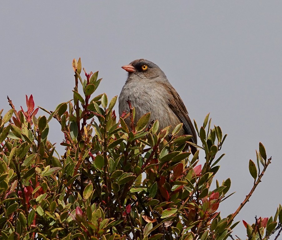
Volcano Junco

Volcano Junco: Almost every birder who visits the paramo in Costa Rica wants to see the Volcano Junco, and not because it is the only Junco in Costa Rica. Mostly they want to see it because it is one of the few birds exclusively limited to the area above tree line, so its range in Costa Rica is very limited. It is not endemic to Costa Rica, but almost. You can see it on the highest peaks in Northern Panama, just over the border. Fortunately it is very easy to see (unlike the other iconic bird of the paramo, the Timberline Wren which can be very elusive). If you drive up to the top of Cerro Buenavista and park under the first antennas you are likely to see one as soon as you get out of the vehicle…feeding on the ground or in the bushes around the buildings there. There have been days when I have visited that were so bad…cold, windy, and misty, with a visibility of just a few yards…that the Volcano Junco was the only bird we saw on the paramo, but we have always seen at least a few. Sony Rx10iv at 320mm equivalent. Program mode with my custom birds and wildlife modifications. Processed in Pixelmator Photo and Apple Photos. ISO 100 @ f6.3 and 4.5 @ 1/1000th.